A conversation with Mojan Kavosh, Rome Scholar in Architecture, in which she speaks about her project “Terra-Firma: Surveying was Art Before the Advent of Digital Cartography and the Paradigm Shift of Map Making”, and the work she has produced during her residency at the BSR from September to October 2024, ahead of the Winter Open Studios.
This is how I’ve enjoyed introducing my project at the BSR: “I am in Rome for a grand church walk.”
In all conscience, my focus on the churches of Rome has brought me here to explore their unchanging didactical typology, not formalistically, but only conditionally. When we think of Rome, the Eternal City, we think of an unchanging urban topography, strolling down Campidoglio or Campo de’ Fiori, re-living the 18th century experience. However, this fixation over the imperishable historical city, today, is a myth when most of what remains as iconic monuments are monetised or on the verge of becoming so; in recent news the Pantheon or even more surreal to imagine a street fountain, the Trevi, becoming ticketed. But of course, this permanence is only the physical fidelity of heritage conservation.
At the core of my research, I strive to use historical contexts to inform contemporary issues while critically engaging with the shift from architectural drafting to the dominance of hyperbolic imagery in today’s professional practice.Throughout my studies and training, I’ve always navigated the space between art and architecture. In the process, I’ve become aware of the challenge inherent in this intersection, that is the question of representation; a medium for conveying the information essential to materialising any city, town or building. Through projects such as Terra-Firma (Land Signatures), that I’ve brought to Rome, I’m trying to initiate a conversation by outlining the intricate relationship between Rome’s churches as monuments and their condition, which is an inquiry that inevitably leads to a broader discussion on the interplay between architecture and abstraction. The history of abstraction in architecture, is a history of conditions. Conditions that are social, political and or economic that do give rise to form, but also redefine how form and function mediate aspects like accessibility and engagement within their context.
Walk 4: Pantheon, Rome 2024. Post ticketing service. Photo by artist
Trevi Fountain, Rome 2024. Fountain emptied for maintenance work and authorities have announced a ticketing service to reduce crowds. Photo by Finlay McGregor
Why focus only on the churches in Rome? Over the past couple of years, I’ve come to see my work in architecture as being a lot like a surveyor’s. Archiving, measuring, tracing, mapping, and breaking down contextual research to create drawings that speak for themselves have become central to my approach to representation. Historically, land surveyors played a key role in mapping landmarks and monuments, crafting simplified narratives to help in record-keeping or military planning. Today, with digital tools quickly providing maps with pin-point accuracy, we’ve lost the artistic touch that surveyors once brought to their work. This split between art and navigation mirrors what’s happening in the construction industry, where the craft of illustration has also taken a back seat. One of the most striking examples of this lost artistic quality is the 1748 Pianta Grande di Roma (Grand Plan of Rome) by architect and surveyor Giambattista Nolli. This map not only shows the lost balance between the surveyor’s empirical work and artistic expression but also serves as a measure of the public spaces around Rome’s monuments in the 18th century. Through illustrating an area that has been largely preserved, this map allows us to make shifts in the perception of “public” tangible, by comparing nearly 300 years later, how the condition of its monuments has changed. Many of the places shown in white on the Nolli map no longer align with the idea of ‘open’ spaces today. I was so struck by this, upon visiting Rome in the summer of 2022 (back then the Pantheon was still free to enter), that I decided to start the Terra-Firma project which I am developing at the BSR. I also realised on that visit that the churches of Rome embody the city’s enduring conditional presence, which is why I am now here doing the grand church walk.
Nolli map scan, with kind permission of ® Bibliotheca Hertziana, Photographic Collection. Drawing overlay by artist
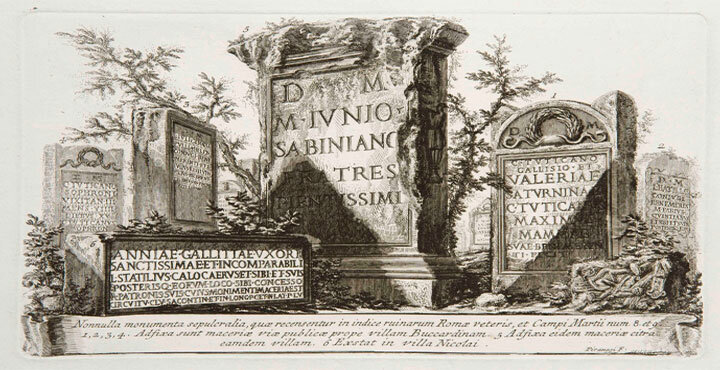
I want to rethink what public space means using the canon of architectural drawing as a tool. I’m deeply inspired by drawing methods that use monuments as nodes of reference, transcending the notion of time by stripping context down to absolute necessity: From the 1st-century AD Roman works of Flaccus and Frontinus, Corpus Agrimensorum (The Body of Land Surveyors), to Alberti’s ca. 1450 Città Ideale (Ideal City), Nolli’s 1748 Pianta Grande di Roma, Piranesi’s 1762 Campo Marzio, and so on. Roman surveyor manuscripts have highlighted for me just how essential the grid is to orthogonal drawing techniques. These early manuals categorise illustrations into two main styles: schematic, where grids align neatly with orthogonal projections, and pictorial, where isometric views without human figures only include selective regional topographical details. Building on these traditions, Terra-Firma is a new drawing. Let’s say a revised map of “Rome and it’s monuments” – if you will – that continues the legacy of surveyors’ role in transcribing data into illustration. To achieve this, I employ a grid scale system, much like the Romans did, to structure the composition. I also apply varying scale factors from a fixed centre point, drawing on the work of architect Leon Battista Alberti’s ca. 1450 Descriptio Urbis Romae (Delineation of the City of Rome). In this work, Alberti carries out a survey of Rome by introducing a circular grid he calls the horizon. By placing the body and peripheral vision at the centre of the horizon, the nodes are drawn closer together by the grid’s curved distortion, yet the survey remains accurate.
“The Roman Land Surveyors: an introduction to the agrimensores” O. A. W. Dilke, 1971. Book scan by artist
Remove and replace context with a grid to augment the distances between nodes. Drawing by artist
Another key reference that has brought me to Rome, is the work of architect and engraver Giuseppe Vasi’s 1763 ItinerarioIstruttivo (Instructional Itinerary). Vasi wrote this itinerary to guide the visiting British and Northern European nobility through the wonders of Rome. What stands out is his decision to break down the magnum opus of the Nolli map into eight distinct walks, with an impressive 117 of 222 sites dedicated to church buildings. The focus on churches in the 18th century is interesting to me, especially at a time when antique ruins and medieval campaniles were recognised and seamlessly integrated into the cityscape as part of everyday life. It’s telling that amongst all monuments in the city, the churches, acting as quasi-secular structures were as, if not more, important than those secular monuments. A hint at the churches of Rome for their visual and spatial significance rather than their religious status or Catholic teachings especially to a largely Protestant audience – even in the 18th century. Ultimately, today, while efforts to limit the accessibility of monuments persist, the city’s churches remain an enduring exception within the pedagogy that history has to offer.
Top: 8 days walk in Rome from “Itinerario Istruttivo”, Guiseppe Vasi 1763. Bottom left: 117 out of 222 devised sites by Vasi are churches in “Itinerario Istruttivo”. Bottom right: All the churches listed by Nolli, which some are no longer extant. Drawings by artist
I came to Rome with the plan to walk Vasi’s eight-day instructional itinerary and to collect a detailed record of the abundant churches listed by Nolli, (more than those mentioned by Vasi) along the way. To date, there are 237 extant churches mapped out by Nolli within the Aurelian Walls, a testament to Rome’s rich and layered history. Over the past two months, I’ve completed four days of the itinerary and have covered 132 churches, each one offering its own story and unique character. Walking the churches of Rome has been nothing short of a grand experience, and for a three-month residency, I couldn’t imagine spending my time any other way. It’s a journey that not only deepens my understanding of Rome but also reaffirms the city’s enduring spirit as a public museum of art and history.
Walk 3: Kavosh at the entrance of Santa Croce e San Bonaventura, Rome. Photo by Finlay McGregor
Walk 1: Maintenance on the sanctuary of Basilica di S. Clemente, Rome 2024. Photo by artist
Walk 2: Corridors connecting to the sacristy, San Carlino alle Quattro Fontane, Rome 2024. Photo by artist
Walk 3: Ceiling fresco The Apotheosis of Saint Dominic, 1674 by Domenico Maria Canuti. Chiesa dei Santi Domenico e Sisto, Rome 2024. Photo by artist
There are other aspects of the Nolli map that fascinate me, one being how he consistently draws churches with their exposed structural plan. In doing this he highlights their unique connection to the street within a horizontal reading of the city. As an extension of his work, Terra-Firma takes a different angle, literally, by introducing the aspect of height. My approach to drawing the churches in planometric view from below is a way to emphasise their distinctive vertical dimension, offering a closer and more spatial understanding of them. This approach can offer a comprehensive representation of these structures where the facade, interior walls and grand ceilings all play a major part in the overall spatial experience.
Floor to ceiling planometric vertical extrusion from below. Santa Maria del Popolo, Rome. Drawing by artist
Prototype itinerary mapping, From Piazza del Popolo toward Campidoglio. Rome. Drawing by artist
In the last months, this process has evolved into a growing compendium, like an atlas dedicated to these churches by zooming into the Nolli map. The quantity of buildings I’ve drawn and printed highlights the scope of Nolli’s map, these spaces in the city, and the extent of this project. I like displaying these plans isotropically on my studio wall, arranged in a grid at the same scale, as I find this presentation creates a powerful sequel and communicates a great deal with visitors. It effectively communicates my intent in not ranking the buildings based on their form, instead offering a comparison that focuses solely on their condition, conveyed through the use of black and white.
In general, what makes this endeavour even more exciting for me is the fact that these monuments remain open to the public today. It’s a way of abstracting their essence while reflecting on a shared experience. This wall becomes more than an arrangement of drawings; it’s an evolving dialogue on the architecture of accessibility and openness that these spaces represent. I truly believe we’ve lost the plot when it comes to the issue of public space. However, I also believe there are many compelling ways to redirect the conversation by revisiting how things were done in the past.
Walk 1-4 plan compendium, Kavosh BSR studio wall 2024. Photo by Can Gun
Walk 1: The extension of the street is a shared experience. Santa Maria del Popolo, Rome 2024. Photo by artist
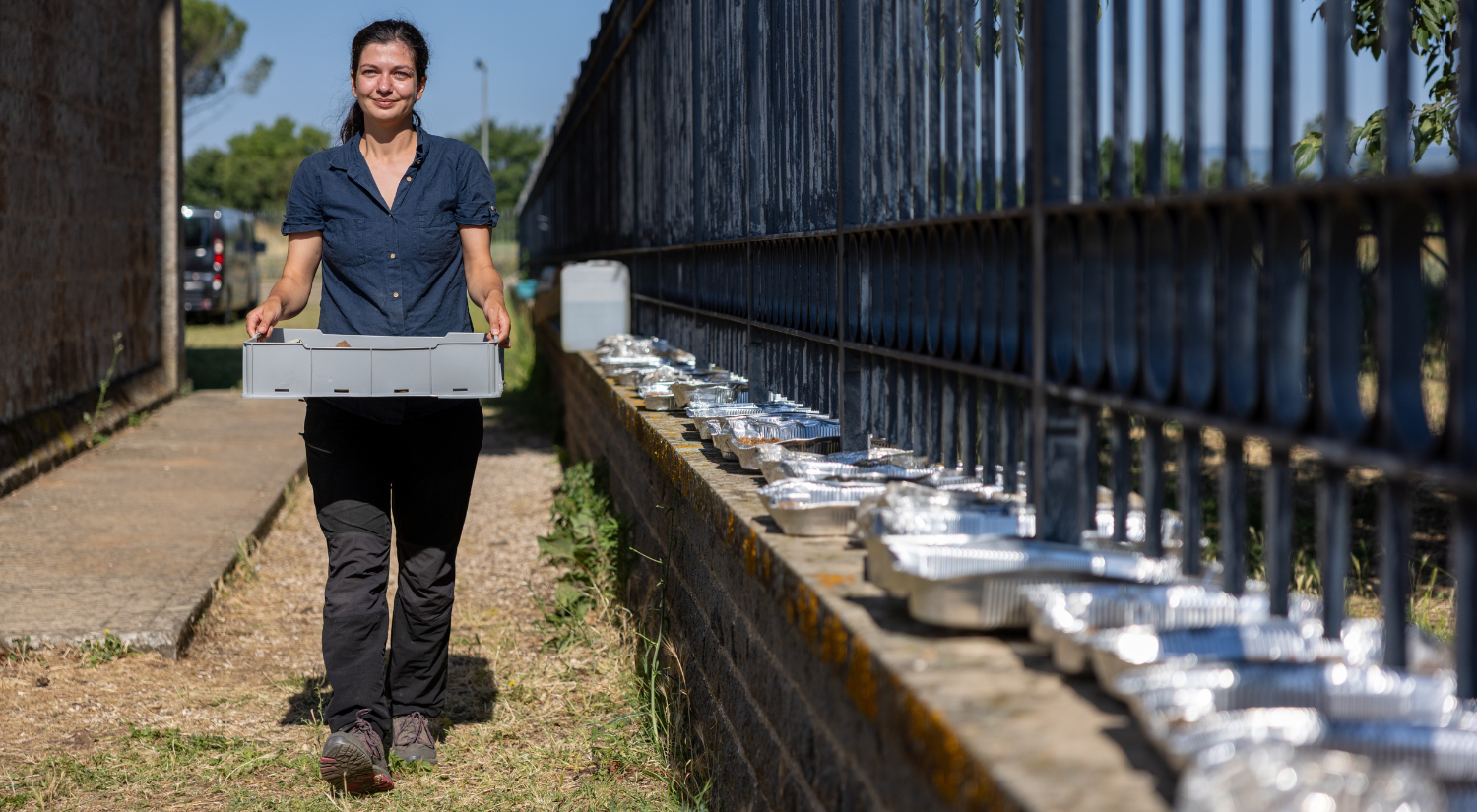
Emma Richard-Trémeau is undertaking a Collaborative Doctoral Award at the University of Durham and BSR. As part of her training, she spent a placement month
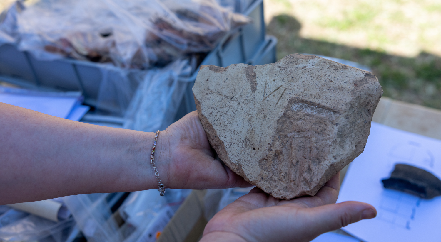
Among the most remarkable finds from the excavation at Falerii Novi is a fragment of architectural terracotta dating to the second century BCE, a reminder
Emma Richard-Trémeau is undertaking a Collaborative Doctoral Award at the University of Durham and BSR. As part of her training, she spent a placement month
Among the most remarkable finds from the excavation at Falerii Novi is a fragment of architectural terracotta dating to the second century BCE, a reminder
This year Falerii Novi tells the story not only of the wealthier members of society but also of the normal citizens in Roman period -
We use cookies on our website to give you the most relevant experience by remembering your preferences and repeat visits. By clicking “Accept All”, you consent to the use of ALL the cookies. However, you may visit "Cookie Settings" to provide a controlled consent.
This website uses cookies to improve your experience while you navigate through the website. Out of these, the cookies that are categorized as necessary are stored on your browser as they are essential for the working of basic functionalities of the website. We also use third-party cookies that help us analyze and understand how you use this website. These cookies will be stored in your browser only with your consent. You also have the option to opt-out of these cookies. But opting out of some of these cookies may affect your browsing experience.
Necessary cookies are absolutely essential for the website to function properly. These cookies ensure basic functionalities and security features of the website, anonymously.
Cookie
Duration
Description
cookielawinfo-checkbox-advertisement
1 year
Set by the GDPR Cookie Consent plugin, this cookie records the user consent for the cookies in the "Advertisement" category.
cookielawinfo-checkbox-analytics
11 months
This cookie is set by GDPR Cookie Consent plugin. The cookie is used to store the user consent for the cookies in the category "Analytics".
cookielawinfo-checkbox-functional
11 months
The cookie is set by GDPR cookie consent to record the user consent for the cookies in the category "Functional".
cookielawinfo-checkbox-necessary
11 months
This cookie is set by GDPR Cookie Consent plugin. The cookies is used to store the user consent for the cookies in the category "Necessary".
cookielawinfo-checkbox-others
11 months
This cookie is set by GDPR Cookie Consent plugin. The cookie is used to store the user consent for the cookies in the category "Other.
cookielawinfo-checkbox-performance
11 months
This cookie is set by GDPR Cookie Consent plugin. The cookie is used to store the user consent for the cookies in the category "Performance".
CookieLawInfoConsent
1 year
CookieYes sets this cookie to record the default button state of the corresponding category and the status of CCPA. It works only in coordination with the primary cookie.
elementor
never
The website's WordPress theme uses this cookie. It allows the website owner to implement or change the website's content in real-time.
viewed_cookie_policy
11 months
The cookie is set by the GDPR Cookie Consent plugin and is used to store whether or not user has consented to the use of cookies. It does not store any personal data.
Functional cookies help to perform certain functionalities like sharing the content of the website on social media platforms, collect feedbacks, and other third-party features.
Performance cookies are used to understand and analyze the key performance indexes of the website which helps in delivering a better user experience for the visitors.
Analytical cookies are used to understand how visitors interact with the website. These cookies help provide information on metrics the number of visitors, bounce rate, traffic source, etc.
Cookie
Duration
Description
_ga
1 year 1 month 4 days
Google Analytics sets this cookie to calculate visitor, session and campaign data and track site usage for the site's analytics report. The cookie stores information anonymously and assigns a randomly generated number to recognise unique visitors.
_ga_*
1 year 1 month 4 days
Google Analytics sets this cookie to store and count page views.
_gat_gtag_UA_*
1 minute
Google Analytics sets this cookie to store a unique user ID.
_gid
1 day
Google Analytics sets this cookie to store information on how visitors use a website while also creating an analytics report of the website's performance. Some of the collected data includes the number of visitors, their source, and the pages they visit anonymously.
CONSENT
2 years
YouTube sets this cookie via embedded YouTube videos and registers anonymous statistical data.
Advertisement cookies are used to provide visitors with relevant ads and marketing campaigns. These cookies track visitors across websites and collect information to provide customized ads.
Cookie
Duration
Description
VISITOR_INFO1_LIVE
5 months 27 days
YouTube sets this cookie to measure bandwidth, determining whether the user gets the new or old player interface.
YSC
session
Youtube sets this cookie to track the views of embedded videos on Youtube pages.